Autumn in New York

       
  A cruise from the Rockaway Inlet through NY Bay and up the Hudson River a day after a freakish (or maybe the new normal) snowstorm hit the area and left millions of people without power, the sun was shining, the sky was blue and the Fall foliage was in full bloom.

First, the Brooklyn oceanfront......
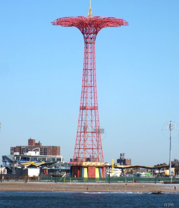
Coney Island is undergoing a transformation; for over 100 years it has been an amusement park and beach for the working class masses, now it's losing the honky-tonk charm for a bland theme-park renovation.
The old, and landmark, Wonder Wheel and Parachute Jump bookend the new attractions.


Under the Verrazano Narrows Bridge, passing Liberty and Ellis Islands, Governors Island and the Manhattan skyline comes into view.....


One World Trade Center still under construction
Around the tip of Manhattan and up the Hudson....

            a fireboat puts on a display in front of Battery Park City
   midtown and the west side piers 
  uptown Riverside Church and Grant's Tomb
 pretty sailboats on both sides


approaching the George Washington Bridge with the Little Red Lighthouse at it's feet
The Cloisters at the northern end of Manhattan    
   on the New Jersey side to the west, the Palisades Interstate Park
the cliffs rise higher as you head north
        nearing the Tappen Zee Bridge and the end of the park

and of course, a bit of history:  The Palisades appear on one of the first European maps of the New World in 1541, based on the description of the explorer Giovanni de Verrazano. Before the creation of the park, all of the Palisades had been in private hands, the lower portion consisting mostly of riverfront villages and the upper section of large estates.  
stereoscopic views from 1865, 1875 and 1880

In the 19th century the cliffs were also widely quarried for railroad ballast, leading to the efforts to preserve them. 

Due to the work of the New Jersey Federation of Women's Clubs, the Palisades Park Commission was founded in 1900, which was authorized to acquire land for a 13-mile stretch between Fort Lee, NJ and Piermont, NY.  Mary Averell Harriman, widow of the Union Pacific Railroad president, offered the state another 10,000 acres and one million dollars toward the creation of a state park. George W. Perkins, head of the commission, raised another $1.5 million from a dozen wealthy contributors including John D. Rockefeller and J. Pierpont Morgan. Rockefeller also bought up and donated land to the park to ensure no development would spoil the view from the Cloisters.


Only a handful of historic houses remain in the park, including the c.1760 Kearney House which is now a museum. The house is believed to have been used by British General Cornwallis during the Revolutionary War.
   1776 depiction of Cornwallis' troops

The Kearney's moved into the house in the early 1800's and expanded it to include a tavern, the park commission bought it and used it as a park police station in the early 20th century.

 yesterday and today


    heading back...into the sunset


historic images; LoC, MCNY,NYPL and njpalisades.org
all others copyright nycedges 2011


The Lost Colonies of Staten Island pt1; The Farm Colony


The Richmond County Poor Farm was established in 1829 as a place where the indigent could receive room and board in exchange for work. When Staten Island became a borough of New York City in 1898, the city assumed responsibility for the property and renamed it the New York City Farm Colony, the residents planted and harvested crops and raised livestock.  By the 1900s, there were 824 residents supervised by 150 employees and 63 acres of the 104 acre site were under cultivation. The food they produced exceeded their needs and the excess was sold to other institutions.
The first building went up in the 1830's, by the turn of the century there were seven dormitories and staff buildings in a campus-like setting within the site.


NY Tribune 1903

  Things began to change in 1924 when jurisdiction over the site was transferred to the city's Homes for Dependents agency which lifted the requirement that all residents of the colony had to work. By 1936 more buildings were added as the Farm Colony’s population grew to 1,428, most of them elderly or disabled.

With the advent of Social Security and the programs of the Great Society implemented in the 1960s the Farm Colony was no longer needed to care for the indigent. Slowly, those still remaining were transferred to other facilities, including Sea View Hospital just across the road. The facility was finally closed in 1975. A number of famous as well as infamous people lived or worked at the Farm Colony including Dorothy Day and Peter Maurin co-founders of the Catholic Worker (citation? see comments) Alice Austen who lived there briefly in the 1950's before her photographs were "rediscovered" and Willie Sutton, the famous bank robber, who hid out there for a few years by working as a porter in the 1940s.

Since its closure the site has been the focus of debate over land use. In 1980 the city attempted to sell the property to developers, but environmentalists and local residents resisted the sale. The City transferred 25 acres to the Parks Department which annexed the section to the Greenbelt -- the remaining acres, along with the Sea View complex, were officially designated a city landmark in 1985. None of the plans for the site have come to fruition and it has been left abandoned.

                                                                                                                     one of the roads

                                                                                                             one of the dormitories


watch your step


the greenhouse


                                                           the kitchen and dining hall

                              the Parks Dept. Greenbelt Recreation Center, the only restored building


archival photos from the Staten Island Advance and Staten Island Historical Society
all other photos copyright nycedge 2011


A View from Under the Bridge: Staten Island (part 2)


Fort Wadsworth can lay claim to being the oldest continuously manned military installation in the U.S.
Strategically located on the banks of the Verrazano Narrows, the entrance to New York Harbor, it began as a Dutch built blockhouse in the 1660's. Known as Flagstaff Fort during the American Revolution, it was occupied and expanded by the British until their final retreat in 1783, fortified by New York State in 1806 and reverted to Federal control during the War of 1812.

                        1854 etching; Staten Island to the left, Brooklyn to the right, and Manhattan at upper right

Construction of the waterfront Battery Weed began in 1847 based on designs recommended by Cpt. Robert E. Lee who was also involved in the construction of Ft. Totten's battery, both were rendered obsolete during the Civil War due to advances in artillery fire power. The fort continued to be fortified, improved and expanded  until 1994 when it was turned over to the National Park Service.

                                              view from Ft.Hamilton in Brooklyn painted by Seth Eastman in 1870  


late 19th & early 20th century;


                                                                                                    1891 water view

                                                                                       artist's rendering from a 1900's postcard

                                                                   the big guns


early 21st century;


from 1859-76 army engineers built these granite dry moats to protect the fort's back and sides from land based attacks

                                                                       a peek inside the fort's interior quad


                                                           Battery Duane from the 1960's

                             Battery Duane today; the Parks Dept. brought in the goats as nature's weedwackers


           The Lighthouse on Battery Weed was built in 1903, restored and converted to solar power in 2005.


The old fort is only open to visitors during Park Ranger tours, the newer structures on the south side are still in use by the Coast Guard, DoD (Homeland Security)...and by the mounted police unit.


                                                                                                           got any treats?

the beach at the turn of the century...

                                                                                                
 from the 1970s when it was off limits due to water pollution...


  ....and today


looking west; beyond the old pier, the WPA built F.D.R. Boardwalk which extends 2.5 miles across the South Beaches to Millers Field, another military installation on the beach....stay tuned.


archival photos courtesy of LoC and Museum of the City of New York
all other text and photos copyright nycedges 2011